Climate change made Helene’s rainfall more severe
Posted on 8 October 2024 by Zeke Hausfather
This is a re-post from the Climate Brink
Much of my immediate family lives in Asheville and Black Mountain, NC. While everyone is thankfully safe, this disaster struck much closer to home for me than most. There is lots that needs to be done for disaster relief, and I’d encourage folks who can to donate to the recovery effort.
But as Western North Carolina and other areas of the Southeastern US work to recover after the catastrophic flooding caused by Helene, its worth exploring the role that climate change may have played in the event.
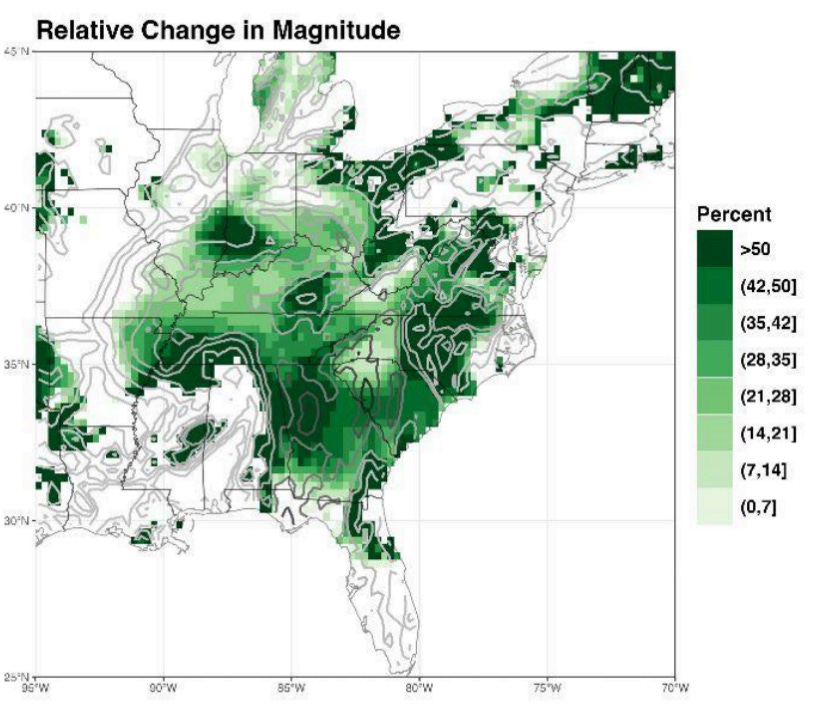
While Helene would have been a disaster even in a world without climate change, the intensification of severe rainfall events is one of the most clear-cut impacts of a warming world. Research in recent years has found that intensification of rainfall during hurricanes is particularly pronounced, and a very preliminary analysis by researchers at Lawrence Berkeley National Laboratory (LBNL) finds that rainfall from Helene could have been increased by up to 50% in some regions by the warming the world has experienced over the past 170 years.
Simply put, warmer air can “hold” more water before it precipitates out, and the amount of moisture in the atmosphere is expected to increase by up to 7% per degree of warming. This, in turn, is expected to increase the severity of heavy precipitation events almost everywhere in the world – even if the average amount of rainfall does not change.
The figure below, from Fischer et al 2014, shows the percent change in heavy precipitation (defined as the highest daily precipitation experienced each year) across the CMIP5 ensemble of climate models as a function of global warming. Changes are shown per degree C, and scale relatively linearly with warming, and stippling represents areas where models agree on the sign of the change. Almost everywhere in the world is expected to see increases in heavy precipitation, with the exception of a few areas over the ocean.
Percent change in heavy precipitation per degree warming, defined as the heaviest daily precipitation event of the year for each location. Figure from Fischer et al 2014.
There is also evidence that this relationship between warming and rainfall is even stronger in hurricanes, which can result in “super-scaling” of the Clausius-Clapeyron relation that governs increases in atmospheric water vapor and temperature. As Liu et al 2019 note, “the percentage increase for inner-core tropical cyclone rainfall rates in our model is markedly larger than the Clausius-Clapeyron rate” and scales with storm intensity. They found that rainfall from tropical storms increases by 13% per degree C to 17% per degree C (e.g. an increase 17% to 22% at current warming levels of 1.3C above preindustrial).
The underlying climate physics discussed above suggests that climate change made Helene’s rainfall more severe. While it will be some time before formal attribution studies are published, three researchers at Lawrence Berkeley National Laboratory published a rapid attribution assessment (building off their prior work assessing Hurricane Harvey).
Their results, shown in the figure below, show a range of precipitation enhancement across the region, with some parts of central and western North Carolina seeing an increase in precipitation of over 50% compared to what would have happened in the absence of historical warming.

Relative change in precipitation magnitude for hurricane Helene compared to a preindustrial climate, from Risser et al. 2024
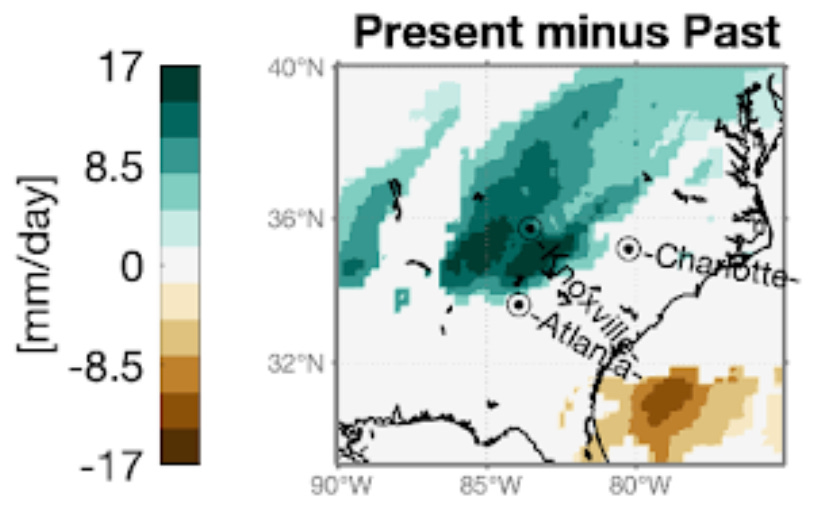
Another estimate from the European group ClimaMeter found more modest enhancement of rainfall, by up to 20% in some parts of the region, as shown in the figure below.

Relative change in precipitation magnitude for hurricane Helene compared to a preindustrial climate, from ClimaMeter 2024
Both of these analyses are very preliminary, coming only a few days after the event. It will take time for additional research and modeling to be done, so we should be a bit cautious in citing firm numbers for precisely how much rainfall was intensified by historical warming, even if its clear that it was intensified.
Even in the absence of historical warming, Helene would likely have brought disastrous flooding to the region, coming on the heels of other storms that had heavy precipitation and primed the region for flooding. While it was exacerbated by climate change and we should plan for the impacts of a warmer world, we also need to better adapt to the types of extremes we have already experienced in the past.
In 1916 the remnants of a hurricane caused the Swannanoa River at Biltmore NC, near Asheville, to rise to 20.7 feet, a record that was only surpassed last week when the river reached 26.1 feet in the aftermath of hurricane Helene. That event caused catastrophic damage to the region, killing more than 80 people.
While there are some different decisions that city planners might make in responding to a 100-year event vs a 20-year event (which might be what we’d expect in a warmer future), we still do a woeful job planning for 100 year events that have occurred in the past today. Much of the work that needs to be done for climate adaptation is to adapt to the climate that exists today, in addition to the climate change adaptation needed to respond to future warming, and we don’t spend enough time talking about this fact today.
